Pages

Welcome!

Through a variety of audiovisuals, Lower School students document their class experiences.

msolberg@cotopaxi.k12.ec


Friday, March 22, 2013

Satellite Education (By J.A.D., J.M., I.M, J.E.V, and A.Z)

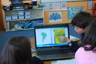
Using HERMES-Delta to answer WDLC questions.
Setting up our live satellite downloads.
Satellite education has many helpful uses. We use satellite education, especially with math, because it helps us calculate many things.  Another way we use satellite education is by downloading LIVE satellite images with the HERMES-Delta program that the Ecuadorian Civilian Space Agency (EXA) lets us use. When we download images we analyze them to know if there will be changes in precipitation and/or temperature, so we can try to forecast the weather. We can also use satellite images to help us find the mean, median, mode and range. Sometimes for math we also use the WDLC, which stands for NASA’s online Weather Data Learning Center. The WDLC also has a book of lessons, and we use our own satellite images of South America to help us find the answers. We fourth graders think that satellite education is very important for math and the world, because it can help us to be better prepared.

P.S. HERMES-Delta and the WDLC are really helpful, but not as cool as having fun with our teacher Ms. Margot.

Connecting math concepts with authentic learning.

No comments:

Post a Comment